|
Welcome to Asotin
County Washington Genealogy Research

Asotin from the hillside 1880
My name is Bob
Jenkins and I created this
website to provide genealogy
information and links to genealogy
information to assist people in
researching
their Asotin County Washington
ancestors.
I would appreciate any
contribution that you would like to
make to this site:
biographies, obituaries, birth,
marriage, death info, grave info,
photographs....etc
|
Use the box below to
search
for Asotin
County Data
|
Brief
History:
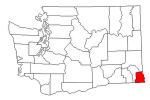
Asotin County (/əˈsoʊtən/) is a county
in the U.S. state of Washington. The
county seat is at Asotin, and its largest
city is Clarkston. The county was created
out of Garfield County in 1883 and derives
its name from a Nez Perce word meaning
"Eel Creek."
The area delineated by the future
Washington state boundary began to be
colonized at the start of the nineteenth
century, both by Americans and Canadians.
However, the majority of Canadian
exploration and interest in the land was
due to the fur trade, whereas American
settlers were principally seeking land for
agriculture and cattle raising. The Treaty
of 1818 provided for dual control of this
area by US and Canadian government
officials. During this period, the future
Washington Territory was divided into two
administrative zones: Clark County and
Lewis County (made official in 1845).
The dual-control concept was unwieldy and
led to continual argument, and occasional
conflict. The status of the Washington
area was settled in 1846, when the Oregon
Treaty ceded the land south of latitude 49
degrees North to American control.
In 1854, Skamania County was split from
the original Clark County. Later that
year, Walla Walla County was split from
the new Skamania County. In 1875, Columbia
County was split from Walla Walla County,
and in 1881, a portion of Columbia County
was set off to form Garfield County. The
southeastern portion of Garfield County
was partitioned in 1883 to form Asotin
County. The 1883 boundary of Asotin has
remained unchanged since then.
|
©
JenkinsGenealogyResearch All Rights
Reserved.
This site last updated:
|


